
The Long Story of Flooding in Pulborough: Past, Present and Future
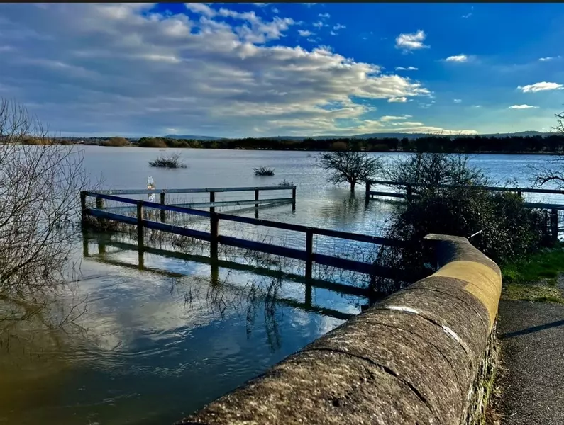
Pulborough’s relationship with flooding is as old as the village itself. Sitting at the tidal reach of the River Arun—one of the fastest‑flowing rivers in England—the community has endured a cycle of river surges, tidal lock, heavy rainfall, and infrastructure challenges that have shaped both its landscape and its identity.
Today, as climate change accelerates extreme weather, understanding Pulborough’s flood history is essential for planning its future.
Flooding is part of Pulborough’s landscape—but with informed residents, maintained watercourses, and coordinated community action, its impact can be reduced.
Why Pulborough Floods
Pulborough lies just below the confluence of the River Arun and the River Rother, at the point where the Arun becomes tidal. This creates a “flashy river with a long tidal tail,” meaning:
- Rainfall runs quickly off Wealden clay, causing rapid rises in river levels.
- Tidal surges push inland up to 41 km, locking the river and preventing water from draining away.
- High spring tides + heavy rainfall can cause simultaneous river and tidal flooding.
This combination makes Pulborough, Amberley, and Arundel among the most flood‑prone communities in West Sussex.
Timeline of Significant Flood Events in Pulborough
1938 – The First Major Flood Alleviation Scheme Proposed
The West Sussex Water Board proposed embankments to protect agricultural land and reduce winter flooding. The scheme was delayed for decades.
September 1968 – Catastrophic Floods
Completion of the long‑delayed embankments coincided with one of the worst floods in Pulborough’s history.
- Water overtopped the new embankments by 0.6 metres.
- Homes north of the Arun were severely flooded. Residents later argued Pulborough had never flooded before this event.
1970–Present – Repeated Overtopping
Since 1970, the embankments have been overtopped five times, reinforcing concerns that agricultural protection worsened urban flooding.
June 2012 – Countywide Flood Event
Heavy rainfall across West Sussex caused widespread surface water flooding. Pulborough was part of a cluster of affected communities, prompting new drainage works and investigations.
December 2013 – Record River Levels
The River Arun reached 4.78 m at Pulborough, the highest level ever recorded.
Winter 2023–24 – Highway Flooding on West Chiltington Road
Heavy rainfall caused significant highway flooding near Mill Cottage, damaging the road and prompting a formal investigation by West Sussex County Council.
2026 – Current Status
As of September 2026, river levels at Pulborough Swan Bridge are within normal range, with no active flood warnings.
Stories & Local Accounts
“We watched the water rise over the embankment…” – 1968 Resident
Residents recall the shock of the 1968 floods, describing water pouring over the newly built embankments and flooding homes that had never previously been at risk.
Farmers vs Residents – A Longstanding Tension
Local opinion has often held that flood schemes prioritised farmland over homes, especially after repeated overtopping events post‑1970.
2023–24: Road Damage and Disruption
West Chiltington Road residents reported days of impassable roads, damaged verges, and concerns about riparian responsibilities. The County Council’s investigation highlighted both drainage failures and landowner obligations.
The Financial Cost of Flooding
Flooding in Pulborough has generated costs across several categories:
- Infrastructure repairs – Road damage, drainage jetting, culvert maintenance, and embankment reinforcement.
- Property damage – Particularly in 1968 and subsequent overtopping events.
- Agricultural losses – Historically significant enough to drive early flood alleviation schemes.
- Countywide flood management programmes – Including Operation Watershed and drainage works following the 2012 floods.
While precise Pulborough‑specific totals are not published, West Sussex’s flood management programmes run into millions of pounds annually, with Pulborough consistently identified as a high‑risk area requiring ongoing investment.
Causes of Flooding: Natural & Human Factors
- Natural Causes
- Rapid runoff from Wealden clay soils.
- Tidal lock preventing river drainage.
- High spring tides and storm surges.
- Increasingly intense rainfall events.
- Human Factors
- Historic embankment design prioritising farmland.
- Development pressure along the floodplain.
- Riparian landowner responsibilities not always met (e.g., blocked ditches, unmanaged culverts).
Climate Change: What It Means for Pulborough
Climate projections for the Arun valley indicate:
- Higher winter rainfall → more frequent river flooding.
- More intense storms → flash flooding and drainage system overload.
- Sea level rise → increased tidal surges reaching Pulborough.
- Flood Zone expansion → Environment Agency models show larger areas at risk by 2070–2125.
Pulborough’s position at the tidal limit makes it especially vulnerable to combined river‑and‑tide events—expected to become more common.
What Residents Can Expect in the Future
- More Frequent Flood Alerts
Although 2026 levels are normal, long‑term trends point toward more regular warnings.
- Continued Infrastructure Works
Expect ongoing drainage improvements, culvert upgrades, and Operation Watershed projects across the parish.
- Greater Emphasis on Riparian Responsibilities
Landowners will face stricter enforcement to maintain ditches, culverts, and watercourses.
- Planning Restrictions
New developments will require robust flood risk assessments, especially near the river.
- Community Preparedness
Flood plans, sandbag stations, and community resilience groups will become increasingly important.
Conclusion
Pulborough’s flood history is a story of geography, infrastructure, and community resilience. From the catastrophic 1968 floods to today’s climate‑driven challenges, the village has continually adapted. As weather patterns intensify, Pulborough’s future will depend on:
- Strong local governance
- Continued investment in flood resilience
- Active participation from residents and landowners
- Transparent communication between authorities and the community
Flooding may be part of Pulborough’s past—but with planning, collaboration, and innovation, it does not have to define its future.
Explainer: Riparian Responsibilities
Pulborough’s rivers, ditches, culverts and streams form a complex network that protects homes, roads and farmland from flooding. But many residents are surprised to learn that much of this system is not maintained by councils—it is legally the responsibility of local landowners. These duties are known as riparian responsibilities.
What Is a Riparian Landowner?
You are a riparian landowner if:
- A watercourse runs through your property
- A watercourse forms the boundary of your property
- A ditch, culvert or stream sits on land you own or manage
This applies whether the watercourse is natural, man‑made, open, or piped.
Your Legal Duties (In Plain English)
- Keep Water Flowing
You must ensure water can flow freely by:
- Clearing vegetation, silt, debris and litter
- Removing fallen trees or branches
- Ensuring banks are stable and not collapsing
- Maintain Culverts and Pipes
If a culvert is on your land, you must:
- Keep it clear
- Repair damage
- Prevent blockages that could cause upstream flooding
- Prevent Flooding and Erosion
You must not:
- Obstruct the watercourse
- Build structures that narrow or block flow
- Redirect water in a way that harms neighbours
- Allow Access for Inspection
Authorities may need access to check flood risk or drainage issues.
Who Does What?
Understanding responsibilities helps avoid confusion during flood events:
- Riparian landowners – Maintain watercourses, ditches, culverts
- West Sussex County Council – Highways drainage, road flooding
- Environment Agency – Main rivers (e.g., River Arun)
- Horsham District Council – Planning, enforcement, environmental health
- Pulborough Parish Council – Community liaison, reporting, resilience support, maintains watercourses, ditches, culverts on parish council owned land
Why It Matters in Pulborough
Pulborough’s flood risk is heavily influenced by:
- Blocked ditches along rural lanes
- Unmaintained culverts on private land
- Overgrown watercourses reducing flow
- Tidal lock causing water to back up when drainage is already compromised
When riparian duties aren’t met, flooding worsens for everyone—including neighbours, farms, and highways.
- Common Misunderstandings
- “The council maintains all ditches.” → Incorrect
- “If the ditch is on the boundary, it’s not mine.” → Often still yours
- “I don’t use the land, so I’m not responsible.” → You still are
- “It hasn’t flooded before, so it’s fine.” → Climate change says otherwise
Practical Checklist for Pulborough Residents
- Inspect ditches twice a year
- Clear vegetation before winter
- Check culverts after heavy rain
- Report issues on main rivers to the Environment Agency
- Work with neighbours—watercourses rarely affect just one property
For more information: Owning a watercourse - GOV.UK
Explainer: Pulborough Community Flood Preparedness Guide
Flooding in Pulborough is a recurring challenge, shaped by the River Arun’s tidal reach, heavy rainfall, and climate‑driven extremes. This guide helps residents prepare, respond, and recover effectively.
Know Your Local Flood Risks
Pulborough faces three main types of flooding:
- River flooding – Arun and Rother overflow
- Tidal flooding – High tides lock the river
- Surface water flooding – Heavy rainfall overwhelms drains.
Report road flooding or an overflowing gully to West Sussex County Council
Floods on roads and roadsides, including blocked gullies, damaged manhole covers, ditches and streams, should be reported to West Sussex County Council. You can do this online or call 01243 642105
High‑risk areas include: Lower St, Swan Bridge, Rivermead, Pulborough Brooks, West Chiltington Road, and low‑lying rural lanes.
Stay Informed
Sign up or look out for:
- Environment Agency Flood Alerts
- WSCC Travel & Road Closure Updates
- Pulborough Parish Council emergency posts on social media
- Check Pulborough Parish Council’s Resilience Plan for guidance and emergency contacts for a range of issues including flooding
Build Your Household Flood Kit
Every home in a flood‑risk area should have:
- Waterproof document folder
- Torch + spare batteries
- First aid kit
- Phone power bank
- Bottled water
- Essential medication
- Warm clothing
- Copies of insurance documents
- List of emergency contacts
Protect Your Property
Before Flood Season
- Install non‑return valves on drains
- Check gutters and downpipes
- Move valuables upstairs
- Keep sandbags or flood boards ready
- Ensure culverts and ditches on your land are clear
- During a Flood Warning
- Move cars to higher ground
- Turn off gas, electricity and water if instructed
- Keep pets indoors
- Avoid walking or driving through floodwater
After Flooding
- Photograph damage for insurance
- Ventilate and dry affected rooms
- Disinfect surfaces
- Check electrical systems before use
Community Resilience
Pulborough benefits from strong community networks. Residents can:
- Help check on vulnerable neighbours
- Share real‑time updates with the community via social media
Travel & Safety
Floodwater on rural roads is dangerous. Remember:
- 30 cm of water can move a car
- Hidden potholes and debris cause accidents
- Contaminated water poses health risks
- Travel with extreme care along West Chiltington Road, Lower St and river‑adjacent lanes during heavy rainfall.
Climate Change: Preparing for the Future
Pulborough will likely see:
- More frequent flood alerts
- Higher winter rainfall
- Increased tidal surges
- Greater pressure on drainage systems
- Long‑term resilience will require:
- Better riparian compliance
- Continued Operation Watershed investment
- Stronger planning controls
- Community‑led preparedness